|
Suggestions and ideas for Slow travel in the project areas
The Po Delta Park of the Emilia-Romagna Region
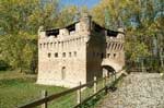
Route in the area of Ferrara. From Mesola to the Unesco Site by boat
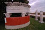
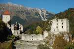
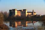 The route starts from the Castello Estense di Mesola, which represents one of the "key plac es" to get acquainted with the delta, where it is possible to visit the Museo del Cervo e del Bosco della Mesola. Going along via Biverare, the route continues to wards the Bosco della Fasanara to the Borgo di Santa Giustina, which introduces you to a significant chapter that has interested the delta of the Po from the beginning of the past century; indeed the hamlet and the houses are clearly visible in the lands reclaimed by the Agency for the colonization of the Po delta. Continuing to wards the woods, you reach Torre Abate, the hydraulic sluice of the Great Reclamation of the House of Este, a building that makes you under stand how the sedimentation of the river, after the Port Viro cut-off, has quickly changed the line of coast, making the construction of other sluices that could guarantee the flow of waters to the sea necessary. Then, the route continues to the Nature Reserve of the Gran Bosco della Mesola. Walking along the main path, as far as the Taglio della Falce, it will be possible to "live" the woods in an exciting way, namely through the en counters (red deer, turtles, etc) and the sounds (jays, crows, etc). Once out of the woods, the route continues to wards the Porto di Goro, where it will be possible to sail to Po di Volano, Valle Bertuzzi and the island Isola dell’Amore or to other places along other waterways. The route starts from the Castello Estense di Mesola, which represents one of the "key plac es" to get acquainted with the delta, where it is possible to visit the Museo del Cervo e del Bosco della Mesola. Going along via Biverare, the route continues to wards the Bosco della Fasanara to the Borgo di Santa Giustina, which introduces you to a significant chapter that has interested the delta of the Po from the beginning of the past century; indeed the hamlet and the houses are clearly visible in the lands reclaimed by the Agency for the colonization of the Po delta. Continuing to wards the woods, you reach Torre Abate, the hydraulic sluice of the Great Reclamation of the House of Este, a building that makes you under stand how the sedimentation of the river, after the Port Viro cut-off, has quickly changed the line of coast, making the construction of other sluices that could guarantee the flow of waters to the sea necessary. Then, the route continues to the Nature Reserve of the Gran Bosco della Mesola. Walking along the main path, as far as the Taglio della Falce, it will be possible to "live" the woods in an exciting way, namely through the en counters (red deer, turtles, etc) and the sounds (jays, crows, etc). Once out of the woods, the route continues to wards the Porto di Goro, where it will be possible to sail to Po di Volano, Valle Bertuzzi and the island Isola dell’Amore or to other places along other waterways.
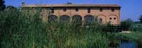
Route in the area of Ravenna. From Sant’Alberto to Boscoforte and Alfonsine..
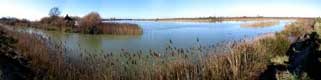
 You can walk, cycle and travel onboard the electri cal bus along this route, which starts from the Visitor Centre Palazzone Sant’Alberto, a build ing of the first decades of the Sixteenth century, located in the south section of the "Valli di Comacchio", which identifies the homonymous hamlet as the enclave of the House of Este (today a Unesco Site) in territory of the Province of Ravenna. From the Palazzone, crossing Sant’Alberto by ferry, you reach the bank of the Reno, which borders the southern area of the Valli di Comacchio. The splendid landscape includes the peninsula of Boscoforte, which has a great naturalistic value and is placed between the Provinces of Ferrara and Ravenna. It is an evocative and uncontaminated place, characterized by a remarkable variety of environments, with freshwater and salt water zones that attract a rich and numerous avifauna and it represents a privileged place for the stop and nest-building of shelducks, avocets, and spoonbills. It is possible to go towards the Nature Reserve of Alfonsine, shelter for numerous species of animals and vegetables or towards the Station Oasis of Volta Scirocco, whose route, which starts nearby Boscoforte, is approximately 6.5 km long. Then you reach Lavadena, with its mosaic of hills covered with halophilic vegetation. Further on, the shallow waters of the Scorticata regularly give shelter to thousands of anatidae, limicolae and ardeidae. From the equipped huts of the flood plain of Volta di Scirocco it is possible to watch, among the others, spoonbills, red herons, black-winged stilts and gadwalls. You can walk, cycle and travel onboard the electri cal bus along this route, which starts from the Visitor Centre Palazzone Sant’Alberto, a build ing of the first decades of the Sixteenth century, located in the south section of the "Valli di Comacchio", which identifies the homonymous hamlet as the enclave of the House of Este (today a Unesco Site) in territory of the Province of Ravenna. From the Palazzone, crossing Sant’Alberto by ferry, you reach the bank of the Reno, which borders the southern area of the Valli di Comacchio. The splendid landscape includes the peninsula of Boscoforte, which has a great naturalistic value and is placed between the Provinces of Ferrara and Ravenna. It is an evocative and uncontaminated place, characterized by a remarkable variety of environments, with freshwater and salt water zones that attract a rich and numerous avifauna and it represents a privileged place for the stop and nest-building of shelducks, avocets, and spoonbills. It is possible to go towards the Nature Reserve of Alfonsine, shelter for numerous species of animals and vegetables or towards the Station Oasis of Volta Scirocco, whose route, which starts nearby Boscoforte, is approximately 6.5 km long. Then you reach Lavadena, with its mosaic of hills covered with halophilic vegetation. Further on, the shallow waters of the Scorticata regularly give shelter to thousands of anatidae, limicolae and ardeidae. From the equipped huts of the flood plain of Volta di Scirocco it is possible to watch, among the others, spoonbills, red herons, black-winged stilts and gadwalls.
Info: Ente di Gestione per i Parchi e la Biodiversità - Delta del Po - C.so Mazzini, 200 - 44022 Comacchio (FE)
Tel. +39 0533 314003 Fax. +39 0533 318007 -
This e-mail address is being protected from spambots. You need JavaScript enabled to view it
www.parcodeltapo.it - www.parks.it/parco.delta.po.er/index.html - www.regione.emilia-romagna.it/parchi/deltapo/index.html
In search of salt and chalk in the surroundings of Ravenna
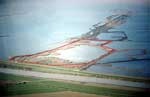
The salt pans in Cervia
 The itinerary takes you to the salt pans in Cervia, in the Po Delta Regional Park, an environment of great interest for its fauna and birdlife, which enables you to expand your knowledge on the naturalistic, historic and economic reasons linked with salt production. The visitors’ centre is the starting point of the guided tours to the salt pans. Three routes can be followed: The naturalistic route, called "the Nest rou-te", takes you along the high banks of the circular canal with purpose-built screens and to a viewing tower from which to birdwatch and observe the birds present in the adjacent ponds and surrounding mounds where it is possible to see rare and protected species nesting in the springtime. The naturalistic-production route takes you on a walk to the famous Camillone Saltmine, an ancient artisanal mine from where you can continue by electric boat to the salt basins where the salt crystallizes. The historic route called "The Tamarisk Route" takes you to the heart of the salt pans. On the way it is possible to birdwatch or enjoy the flora and fauna, the history of Cervia and its ancient links with salt. The itinerary takes you to the salt pans in Cervia, in the Po Delta Regional Park, an environment of great interest for its fauna and birdlife, which enables you to expand your knowledge on the naturalistic, historic and economic reasons linked with salt production. The visitors’ centre is the starting point of the guided tours to the salt pans. Three routes can be followed: The naturalistic route, called "the Nest rou-te", takes you along the high banks of the circular canal with purpose-built screens and to a viewing tower from which to birdwatch and observe the birds present in the adjacent ponds and surrounding mounds where it is possible to see rare and protected species nesting in the springtime. The naturalistic-production route takes you on a walk to the famous Camillone Saltmine, an ancient artisanal mine from where you can continue by electric boat to the salt basins where the salt crystallizes. The historic route called "The Tamarisk Route" takes you to the heart of the salt pans. On the way it is possible to birdwatch or enjoy the flora and fauna, the history of Cervia and its ancient links with salt.
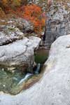
The Vena del Gesso Regional Park in the Romagna Region
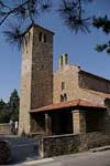
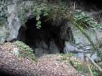 The route is in the heart of the Vena del Gesso Re-gional Park in the Romagna region; starting from the railway station in Brisighella, a gorgeous medieval hamlet, the itinerary (approximately 5km) continues to the visitors’ centre in Carnè, through picturesque hills and woods. From the historical centre of the medieval hamlet of Brisighella, you walk along the charming via del Borgo, also known as via degli Asini because it was once travelled by donkeys making their way to the chalk caves. It is a raised and covered road that was originally the centre of defence of the fortified hamlet. Following the CAI (Italian Alpine Club) path you arrive at the Speleological hut, the meeting place from which to enter the Tanaccia Cave. From here it is possible to take a guided visit to the caves with a Park guide, using helmets with lights. The route continues to Cà Carnè, headquarters of the visitors’ centre and a refuge with restaurant and accommodation. The small but interesting naturalistic museum dedicated to the fauna of the Vena del Gesso is worth a visit. The CAI route takes you along the Monte Spugi peak, through vineyards and orchards, to the Vespignano Oratory. Then, in Castelnuovo you enter the woods again. On the way back to Cà Carnè you descend towards Brisighella and stop at Monticino, an open-air geological museum dug into a former quarry, at the old twentieth-century Malpezzi chalk kiln and at the medieval Fortress that dominates the hamlet. The route is in the heart of the Vena del Gesso Re-gional Park in the Romagna region; starting from the railway station in Brisighella, a gorgeous medieval hamlet, the itinerary (approximately 5km) continues to the visitors’ centre in Carnè, through picturesque hills and woods. From the historical centre of the medieval hamlet of Brisighella, you walk along the charming via del Borgo, also known as via degli Asini because it was once travelled by donkeys making their way to the chalk caves. It is a raised and covered road that was originally the centre of defence of the fortified hamlet. Following the CAI (Italian Alpine Club) path you arrive at the Speleological hut, the meeting place from which to enter the Tanaccia Cave. From here it is possible to take a guided visit to the caves with a Park guide, using helmets with lights. The route continues to Cà Carnè, headquarters of the visitors’ centre and a refuge with restaurant and accommodation. The small but interesting naturalistic museum dedicated to the fauna of the Vena del Gesso is worth a visit. The CAI route takes you along the Monte Spugi peak, through vineyards and orchards, to the Vespignano Oratory. Then, in Castelnuovo you enter the woods again. On the way back to Cà Carnè you descend towards Brisighella and stop at Monticino, an open-air geological museum dug into a former quarry, at the old twentieth-century Malpezzi chalk kiln and at the medieval Fortress that dominates the hamlet.
Info: Provincia di Ravenna - Servizio Turismo - Piazza dei Caduti per la Libertà 2/4 48121 Ravenna
Tel +39 0544 506011 -
This e-mail address is being protected from spambots. You need JavaScript enabled to view it
- www.ravennaintorno.itUfficio di Informazione e Accoglienza Turistica - Corso Matteotti 40, Riolo Terme
Tel. +39 0546 71044 -
This e-mail address is being protected from spambots. You need JavaScript enabled to view it
- www.terredifaenza.itUfficio di Informazioni e Accoglienza Turistica - Torre S. Michele, Via Evangelisti 4, Cervia
Tel +39 0544 974400 -
This e-mail address is being protected from spambots. You need JavaScript enabled to view it
- www.turismo.comunecervia.it
Province of Ferrara - Cycling along the Po, through art and natural masterpieces
Right bank of the Po cycle route, 120 km
 One of the longest level cycle routes in Europe that runs from the sea across flood plains, through woods, under bell towers, alongside water works, fortresses, floating water mills, castles and reed beds. 1. Stellata di Bondeno is a small hamlet that lies along the banks of the river and preserves the starshaped Rocca Possente fortress. Its Archaeological Museum keeps the evidences of the events occurred in the territory in different historic periods. 2. Ro floating water mill with its grain grindstone is moored. It is a faithful reproduction of those that inspired the novel "Il mulino del Po" by Bacchelli. 3. Mesola stands out in the distance because of the imposing late 16th-century Castello Estense that is situated by the river and today is the seat of the "Museo del Bosco e del Cervo della Mesola". 4. Gorino Ferrarese is a fascinating environment of transition from the dry land to the valleys, the river and the sea and is the departure point for boat excursions to the Lighthouse on the island "Isola dell’Amore". One of the longest level cycle routes in Europe that runs from the sea across flood plains, through woods, under bell towers, alongside water works, fortresses, floating water mills, castles and reed beds. 1. Stellata di Bondeno is a small hamlet that lies along the banks of the river and preserves the starshaped Rocca Possente fortress. Its Archaeological Museum keeps the evidences of the events occurred in the territory in different historic periods. 2. Ro floating water mill with its grain grindstone is moored. It is a faithful reproduction of those that inspired the novel "Il mulino del Po" by Bacchelli. 3. Mesola stands out in the distance because of the imposing late 16th-century Castello Estense that is situated by the river and today is the seat of the "Museo del Bosco e del Cervo della Mesola". 4. Gorino Ferrarese is a fascinating environment of transition from the dry land to the valleys, the river and the sea and is the departure point for boat excursions to the Lighthouse on the island "Isola dell’Amore".
From the sea to the valleys, 80 km
 The panoramic road along the bank Acciaioli stretches from the Lidi di Comacchio to the quiet spaces of the Valli di Comacchio across some wonderful salt water lagoons and wonderful nature parks to the "Penisola di Boscoforte" and the "Valli di Argenta". 1. Comacchio salt pan, which dates back to Napoleonic times, is home to colonies of sea birds including fabulous pink flamingos. 2. Comacchio is the renowned historic centre with its wellpreserved bridges and canals. To the south, the "Percorso Storico Naturalistico delle Valli" winds from Casone Foce where 17th-century fishing huts and eel catching systems dot the skyline between land and sea. 3. The "Penisola di Boscoforte" can be seen from the banks of the Reno. 4. Argenta with its Ecomuseum and fresh water lagoons covered with water lilies surrounded by willows, English oaks, elms and reed beds is the ideal habitat for waders and other birds and thus an ideal spot for birdwatching The panoramic road along the bank Acciaioli stretches from the Lidi di Comacchio to the quiet spaces of the Valli di Comacchio across some wonderful salt water lagoons and wonderful nature parks to the "Penisola di Boscoforte" and the "Valli di Argenta". 1. Comacchio salt pan, which dates back to Napoleonic times, is home to colonies of sea birds including fabulous pink flamingos. 2. Comacchio is the renowned historic centre with its wellpreserved bridges and canals. To the south, the "Percorso Storico Naturalistico delle Valli" winds from Casone Foce where 17th-century fishing huts and eel catching systems dot the skyline between land and sea. 3. The "Penisola di Boscoforte" can be seen from the banks of the Reno. 4. Argenta with its Ecomuseum and fresh water lagoons covered with water lilies surrounded by willows, English oaks, elms and reed beds is the ideal habitat for waders and other birds and thus an ideal spot for birdwatching
Info: Centro Unificato d’Informazioni Turistiche - Castello Estense 44121 Ferrara
Tel. + 39 0532 299303 - www.ferrarainfo.com -
This e-mail address is being protected from spambots. You need JavaScript enabled to view it
Province of Rovigo - Polesine: a land between two rivers
Soul of Polesine
 This itinerary enables visitors to experience the many souls of Polesine. It starts in the town centre of Rovigo, continues across the greenery of the plain and then along the left bank of the Po River to the north part of the delta. 1. Rovigo’s historic centre offers elegant squares, castle towers, Roverella palace, the Church of Beata Vergine del Soccorso known as "La Rotonda" and the Museum of the Long Rivers that illustrates the history of Polesine. 2. Adria is the town that gave the Adriatic Sea its name. It is an important area for archaeological finds that are kept at the National Archaeo-logical Museum. 3. Via delle Valli is a unique road between fishing valleys, inhabited by waterfowls, and the fishing valleys with typical houses where fishermen produce renowned fish products. 4. Rosolina lido is a peninsula of golden sand between the water of the valleys and the Adriatic Sea, a perfect place to relax and have good time. This itinerary enables visitors to experience the many souls of Polesine. It starts in the town centre of Rovigo, continues across the greenery of the plain and then along the left bank of the Po River to the north part of the delta. 1. Rovigo’s historic centre offers elegant squares, castle towers, Roverella palace, the Church of Beata Vergine del Soccorso known as "La Rotonda" and the Museum of the Long Rivers that illustrates the history of Polesine. 2. Adria is the town that gave the Adriatic Sea its name. It is an important area for archaeological finds that are kept at the National Archaeo-logical Museum. 3. Via delle Valli is a unique road between fishing valleys, inhabited by waterfowls, and the fishing valleys with typical houses where fishermen produce renowned fish products. 4. Rosolina lido is a peninsula of golden sand between the water of the valleys and the Adriatic Sea, a perfect place to relax and have good time.
Polesine: its rivers and art
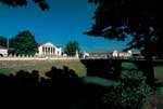 Leaving Rovigo, visitors join the natural bike path on the left bank of the Po River, then leave behind the delta to continue to Fratta Polesine, Lendinara and Badia Polesine passing through the towns situated along minor watercourses. 1. Polesella is a village renowned for its Venetian villas, including Villa Morosini close by the Po River, and for its lovely bicycle path along the ancient Fossa that links the Canalbianco and Po River. 2. Fratta Polesine is a village illuminated by the elegance of Andrea Palladio’s Villa Badoer, which is host to cultural events recounting the territory’s past, seat of the National Archaeological Museum located in the Villa’s barn and Mill Pizzon Ecomuseum. Today, the water mill offers opportunities to taste delicacies typical of Polesine. 3. Lendinara with its churches and stately palace such as Cà Dolfin and Ballarin Theater. 4. Badia Polesine historic centre known for Vangadizza Medieval Monastic Complex. Leaving Rovigo, visitors join the natural bike path on the left bank of the Po River, then leave behind the delta to continue to Fratta Polesine, Lendinara and Badia Polesine passing through the towns situated along minor watercourses. 1. Polesella is a village renowned for its Venetian villas, including Villa Morosini close by the Po River, and for its lovely bicycle path along the ancient Fossa that links the Canalbianco and Po River. 2. Fratta Polesine is a village illuminated by the elegance of Andrea Palladio’s Villa Badoer, which is host to cultural events recounting the territory’s past, seat of the National Archaeological Museum located in the Villa’s barn and Mill Pizzon Ecomuseum. Today, the water mill offers opportunities to taste delicacies typical of Polesine. 3. Lendinara with its churches and stately palace such as Cà Dolfin and Ballarin Theater. 4. Badia Polesine historic centre known for Vangadizza Medieval Monastic Complex.
Info: Ufficio I.A.T. Rovigo - Piazza Vittorio Emanuele II, 20 45100 Rovigo
Tel. +39 0425 386290 -
This e-mail address is being protected from spambots. You need JavaScript enabled to view it
Provincia di Rovigo – Servizio Turismo - Viale della Pace, 5 45100 Rovigo
Tel. +39 0425 386274 -
This e-mail address is being protected from spambots. You need JavaScript enabled to view it
- www.polesineterratraduefiumi.it Gal Polesine Delta Po - Piazza Garibaldi, 6 - 45100 Rovigo.
Tel. +39 0425 460322 -
This e-mail address is being protected from spambots. You need JavaScript enabled to view it
- www.galdeltapo.it
Po Delta Park of the Veneto Region - Horizons between land and water
"Isola della Donzella" and "Sacca di Scardovari"
 It is a cycle route that starts at Porto Tolle and passes through many interesting sites, enabling the visitor to learn about the recent history of the Po Delta and to enjoy unique panoramas of the "Sacca di Scardovari". 1 The Land Reclamation Museum of Ca’ Vendramin is a wonderful example of industrial architecture and a symbol of the history of the Po Delta. The museum houses the old hydraulic machineries and equipment and offers multimedia tools and vintage photos that illustrate the hard work done by man to live with the River. 2 The Pontoon bridge of Santa Giulia is a passage over the river branch consisting of boats connected to each other. One of the most fascinating of the circuit, from here there are excur-sions for fishing and birdwatching along the Po di Gnocca branch. 3 The Nature Oasis of Cà Mello is what is left of the Delta when the Po River of Cà Mello used to flow in the Isola della Donzella and to empty into the Sacca. It is a protected site near the sea and is considerably important for its great biodiversity and the many species of birds of its reed beds. It is a cycle route that starts at Porto Tolle and passes through many interesting sites, enabling the visitor to learn about the recent history of the Po Delta and to enjoy unique panoramas of the "Sacca di Scardovari". 1 The Land Reclamation Museum of Ca’ Vendramin is a wonderful example of industrial architecture and a symbol of the history of the Po Delta. The museum houses the old hydraulic machineries and equipment and offers multimedia tools and vintage photos that illustrate the hard work done by man to live with the River. 2 The Pontoon bridge of Santa Giulia is a passage over the river branch consisting of boats connected to each other. One of the most fascinating of the circuit, from here there are excur-sions for fishing and birdwatching along the Po di Gnocca branch. 3 The Nature Oasis of Cà Mello is what is left of the Delta when the Po River of Cà Mello used to flow in the Isola della Donzella and to empty into the Sacca. It is a protected site near the sea and is considerably important for its great biodiversity and the many species of birds of its reed beds.
To the Po River mouth between reed beds and sand banks
 It is a sailing route by a typical fl atbottomed boat or canoe, in the immensity of the river near its mouth, along narrow channels, as far as the alluvial deposits inhabited only by wild birds. 1. Pila is a typical fishermen’s village with a lovely walk from our starting berth on the Po to the new port facility in Barbamarco lagoon and the characteristic fi sh market open every afternoon. 2. The Lighthouse of Punta Maistra is the foremost point and most suggestive place of the delta peak, which is about 40 meters high. It is surrounded by seamlessly lagoons, salt marshes and delta branches, and has the largest concentration of shorebirds and herons. Under the control of the Italian Navy, it still plays an important role for the safety of navigation. 3. Scano Boa, this long, narrow and sandy island interposed between the inner lagoon and the sea, where one of the last cane huts existing in the Delta can be found, is today the fi shermen’s refuge and one of the symbols of the Po Delta. It is a sailing route by a typical fl atbottomed boat or canoe, in the immensity of the river near its mouth, along narrow channels, as far as the alluvial deposits inhabited only by wild birds. 1. Pila is a typical fishermen’s village with a lovely walk from our starting berth on the Po to the new port facility in Barbamarco lagoon and the characteristic fi sh market open every afternoon. 2. The Lighthouse of Punta Maistra is the foremost point and most suggestive place of the delta peak, which is about 40 meters high. It is surrounded by seamlessly lagoons, salt marshes and delta branches, and has the largest concentration of shorebirds and herons. Under the control of the Italian Navy, it still plays an important role for the safety of navigation. 3. Scano Boa, this long, narrow and sandy island interposed between the inner lagoon and the sea, where one of the last cane huts existing in the Delta can be found, is today the fi shermen’s refuge and one of the symbols of the Po Delta.
Info: Parco Regionale Veneto del Delta del Po - Via Marconi 6 45012 Ariano nel Polesine
Tel. + 39 0426 372202 Fax +39 0426 373035 -
This e-mail address is being protected from spambots. You need JavaScript enabled to view it
- www.parcodeltapo.org
Between water and villas in the area surrounding Treviso
The Prosecco and Conegliano Valdobbiadene Wines Route
 Valdobbiadene belongs to the oldest Italian oenological route, the Prosecco Route, which crosses the production zones to meet the needs of the modern wine tourist who is attracted not only by the great wines and typical products but also by the landscape, environmental and cultural components that make the soul of the territory. With its 120 Km that climb up the Conegliano Valdobbiadene hills, the route crosses a wide area that offers a lot of interesting places rich in history. The oenological routes leads the tourist to uninterrupted vineyards, hamlets and villages where he can breathe the century-old wine art of this territory that offers suggestive views and landscapes, together with medieval evidences, hermitages, century-old churches and traces of the rural and religious history of the local people. Along the route the tourist can find lots of plac-es that serve typical local dishes and products. The route offers the opportunity to choose between the main itinerary, which starts in Conegliano and ends in Valdobbiadene, and three thematic rings: the great feud of the Collalto, History and Culture in Serravalle and Follina, and Torchiato wine of Fregona Valdobbiadene belongs to the oldest Italian oenological route, the Prosecco Route, which crosses the production zones to meet the needs of the modern wine tourist who is attracted not only by the great wines and typical products but also by the landscape, environmental and cultural components that make the soul of the territory. With its 120 Km that climb up the Conegliano Valdobbiadene hills, the route crosses a wide area that offers a lot of interesting places rich in history. The oenological routes leads the tourist to uninterrupted vineyards, hamlets and villages where he can breathe the century-old wine art of this territory that offers suggestive views and landscapes, together with medieval evidences, hermitages, century-old churches and traces of the rural and religious history of the local people. Along the route the tourist can find lots of plac-es that serve typical local dishes and products. The route offers the opportunity to choose between the main itinerary, which starts in Conegliano and ends in Valdobbiadene, and three thematic rings: the great feud of the Collalto, History and Culture in Serravalle and Follina, and Torchiato wine of Fregona
From Conegliano to Oderzo: the countryside on the left bank of the river Piave
 Towns and sites along the route: Conegliano, Co-dognè, Portobuffolè, Mansuè, Gorgo al Monticano, Motta di Livenza, Oderzo. Distance: 55 kilometres. Riding time: Approx. 3 hours. Rider level: Amateur. A visit to the charming town of Conegliano is strongly recommended, since in the town stand many interesting works of art, including the Duomo that houses works by Cima da Conegliano and other renowned artists, the Sala dei Battuti, frescoed houses in Via XX Settembre, the Castle, etc. After leaving Conegliano, one crosses a countryside offering pleasant views of fertile fi elds and beautifully tended vineyards dotted with small villages. This area is greatly renowned for its production of DOC Piave wines. Recommended stops are Portobuffolé, a small medieval hamlet that has fortunately remained practically intact, in the naturalistic area of "Pra dei Gai" and Motta di Livenza that is rich in historic buildings and is particularly famous for the Basilica of the Madonna dei Miracoli built in 1513. Towns and sites along the route: Conegliano, Co-dognè, Portobuffolè, Mansuè, Gorgo al Monticano, Motta di Livenza, Oderzo. Distance: 55 kilometres. Riding time: Approx. 3 hours. Rider level: Amateur. A visit to the charming town of Conegliano is strongly recommended, since in the town stand many interesting works of art, including the Duomo that houses works by Cima da Conegliano and other renowned artists, the Sala dei Battuti, frescoed houses in Via XX Settembre, the Castle, etc. After leaving Conegliano, one crosses a countryside offering pleasant views of fertile fi elds and beautifully tended vineyards dotted with small villages. This area is greatly renowned for its production of DOC Piave wines. Recommended stops are Portobuffolé, a small medieval hamlet that has fortunately remained practically intact, in the naturalistic area of "Pra dei Gai" and Motta di Livenza that is rich in historic buildings and is particularly famous for the Basilica of the Madonna dei Miracoli built in 1513.
Info: Ufficio Informazioni Turistiche di Conegliano - Via XX Settembre, 61 31015 Conegliano (TV)
Tel. +39 0438 21230 Fax +39 0438 428777 -
This e-mail address is being protected from spambots. You need JavaScript enabled to view it
- www.visittreviso.itUfficio Informazioni Turistiche di Oderzo - Calle Opitergium, 5 31046 Oderzo (TV)
Tel. +39 0422 815251 Fax +39 0422 814081 -
This e-mail address is being protected from spambots. You need JavaScript enabled to view it
- www.visittreviso.itUfficio Informazioni Turistiche di Valdobbiadene - Via Piva, 53 31049 Valdobbiadene (TV)
Tel. +39 0423 976975 Fax +39 0423 976975 -
This e-mail address is being protected from spambots. You need JavaScript enabled to view it
- www.visittreviso.it
Slow itineraries between lands and waters in the Province of Venice
From Altino to Torcello
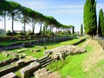
 A tour that allows the visitor to discover the past and the origins of the Venetian civilization through the "signs" of civilizations buried along the borders of the north Lagoon of Venice. From the archaeological museum of Altino, sailing the River Sile to get to the famous islands of Burano and Torcello. 1. The National Archaeological Museum of Alti-no is an important Roman settlement on the ancient Annia road (131 BC) that connected Adria (Rovigo) to Aquileia (Udine). 2. The River Sile, one of the longest European resurgence rivers, flows in an uncontaminated natural environment between Venetian villas and country mansion houses. It allows the navigation from the inland to the islands in the lagoon of Venice. On its banks a cycling route leads to Treviso. 3. The origins of Torcello are more ancient than those of Venice. Escaping from the barbarian hordes, many inhabitants from Altino found refuge in this far corner of the lagoon. They came from the area of Altino called Turris as there was a tower located nearby, for this reason they called Turricellum their new country. A tour that allows the visitor to discover the past and the origins of the Venetian civilization through the "signs" of civilizations buried along the borders of the north Lagoon of Venice. From the archaeological museum of Altino, sailing the River Sile to get to the famous islands of Burano and Torcello. 1. The National Archaeological Museum of Alti-no is an important Roman settlement on the ancient Annia road (131 BC) that connected Adria (Rovigo) to Aquileia (Udine). 2. The River Sile, one of the longest European resurgence rivers, flows in an uncontaminated natural environment between Venetian villas and country mansion houses. It allows the navigation from the inland to the islands in the lagoon of Venice. On its banks a cycling route leads to Treviso. 3. The origins of Torcello are more ancient than those of Venice. Escaping from the barbarian hordes, many inhabitants from Altino found refuge in this far corner of the lagoon. They came from the area of Altino called Turris as there was a tower located nearby, for this reason they called Turricellum their new country.
Along the River Lemene from the lagoon of Caorle to Portogruaro
 The route stretches along the River Lemene across a rural area dotted with historical sites, villas, mills and abbeys. It starts from the Vallevecchia lagoon of Caorle, a land dominated by supreme silence, reed beds and endless expanses of waters inhabited by numerous bird species, to Concordia Sagit-taria, an ancient Roman town, and to Portogruaro, with its Gothic-Renaissance town centre. 1. The fishing hamlet of Caorle with its typical coloured houses, its Cathedral (11th century) and its Sanctuary with the bell tower-lighthouse, lies by its homonymous lagoon with its characteristic fi shing huts made of reeds. 2. The area of Valle Vecchia with its distinctive natural and environmental habitat and dunes recognized as protected area for the conservation of its biological diversity. 3. The River Lemene connects Caorle to Concordia Sagittaria, an important centre of the Roman period, with its Roman and late antique archaeological sites and early Christian complex beneath the cathedral square and to Portogruaro, a charming town with its famous fourteenth-century town hall and its buildings in the Renaissance Venetian style, included in the fi ne wine area of the DOC "Lison Pramaggiore". The route stretches along the River Lemene across a rural area dotted with historical sites, villas, mills and abbeys. It starts from the Vallevecchia lagoon of Caorle, a land dominated by supreme silence, reed beds and endless expanses of waters inhabited by numerous bird species, to Concordia Sagit-taria, an ancient Roman town, and to Portogruaro, with its Gothic-Renaissance town centre. 1. The fishing hamlet of Caorle with its typical coloured houses, its Cathedral (11th century) and its Sanctuary with the bell tower-lighthouse, lies by its homonymous lagoon with its characteristic fi shing huts made of reeds. 2. The area of Valle Vecchia with its distinctive natural and environmental habitat and dunes recognized as protected area for the conservation of its biological diversity. 3. The River Lemene connects Caorle to Concordia Sagittaria, an important centre of the Roman period, with its Roman and late antique archaeological sites and early Christian complex beneath the cathedral square and to Portogruaro, a charming town with its famous fourteenth-century town hall and its buildings in the Renaissance Venetian style, included in the fi ne wine area of the DOC "Lison Pramaggiore".
Info: APT - Venezia Castello - 5050 - 30122 Venezia
Tel. +39 041 5298711 -
This e-mail address is being protected from spambots. You need JavaScript enabled to view it
Ufficio IAT di Caorle - Rio Terrà 3 - 30021 Caorle (VE)
Tel. +39 0421 81085 -
This e-mail address is being protected from spambots. You need JavaScript enabled to view it
APT di Bibione-Caorle - Via Maja 84 - 30020 Bibione (VE)
Tel. +39 0431 442111 Fax + 39 0431 439997 -
This e-mail address is being protected from spambots. You need JavaScript enabled to view it
Towards the Friuli coast: along water and cultural routes
Lands of culture
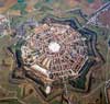 This itinerary makes a plunge into the past possible, namely from the Roman and pre-Christian periods to the Medieval and Renaissance periods, via a fascinating journey across landscapes suitable for walking and cycling. 1. Villa Manin is located in a large park and dates back to the mid-17th century. It hosts ancient and contemporary art exhibitions. 2. Clauiano is a medieval village renowned as one of the most beautiful in Italy. 3. Palmanova is a fortress town and one of the best-preserved examples of Renaissance military architecture. 4. Strassoldo is a small medieval village that hosts two of the most ancient manors in Friuli, the Castle of Strassoldo di Sopra and the Castle of Strassoldo di Sotto. 5. Aquileia, founded by the Romans in 181 BC, is now a Unesco World Heritage site and a wellknown archaeological area. 6. Grado, joined to the mainland by a narrow strip of land, offers a beautiful Venetian-style historic centre. This itinerary makes a plunge into the past possible, namely from the Roman and pre-Christian periods to the Medieval and Renaissance periods, via a fascinating journey across landscapes suitable for walking and cycling. 1. Villa Manin is located in a large park and dates back to the mid-17th century. It hosts ancient and contemporary art exhibitions. 2. Clauiano is a medieval village renowned as one of the most beautiful in Italy. 3. Palmanova is a fortress town and one of the best-preserved examples of Renaissance military architecture. 4. Strassoldo is a small medieval village that hosts two of the most ancient manors in Friuli, the Castle of Strassoldo di Sopra and the Castle of Strassoldo di Sotto. 5. Aquileia, founded by the Romans in 181 BC, is now a Unesco World Heritage site and a wellknown archaeological area. 6. Grado, joined to the mainland by a narrow strip of land, offers a beautiful Venetian-style historic centre.
Water Lands
 This itinerary crosses places that offer natural and beautiful landscapes and makes you plunge, following the flowing of the watercourses, into a green landscape, which by now has almost disappeared. 1. Aquileia is a port that was very important during the Roman period; it can be reached by sea in small boats by taking the River Natissa. 2. The Lagoon of Marano is characterised by islands and lagoons, by swamp vegetation and by fisherman’s temporary homes (casoni). 3. Nature reserve Valle Canal Novo is a protected area and an important centre for the environmental safeguard and scientific research projects, a perfect place for birdwatching. 4. Nature reserve Foci dello Stella is under environmental protection from 1976, so it is especially recommended for naturalistic-educational activities. 5. Lignano is an oasis with a fine sand beach and a calm sea, perfect to relax and have fun. This itinerary crosses places that offer natural and beautiful landscapes and makes you plunge, following the flowing of the watercourses, into a green landscape, which by now has almost disappeared. 1. Aquileia is a port that was very important during the Roman period; it can be reached by sea in small boats by taking the River Natissa. 2. The Lagoon of Marano is characterised by islands and lagoons, by swamp vegetation and by fisherman’s temporary homes (casoni). 3. Nature reserve Valle Canal Novo is a protected area and an important centre for the environmental safeguard and scientific research projects, a perfect place for birdwatching. 4. Nature reserve Foci dello Stella is under environmental protection from 1976, so it is especially recommended for naturalistic-educational activities. 5. Lignano is an oasis with a fine sand beach and a calm sea, perfect to relax and have fun.
Info: Agenzia Turismo Friuli Venezia Giulia c/o Villa Chiozza - Via Carso n. 3 33052 Cervignano del Friuli (UD)
Tel. +39 0431 387111 -
This e-mail address is being protected from spambots. You need JavaScript enabled to view it
- www.turismofvg.it
Trieste: Europe dives into the Adriatic Sea
The Water Forest
 The path winds its way through the harsh Karst plateau: from the Centro didattico naturalistico in Basovizza, a few kilometers away from Trieste, to the Val Rosandra Visitor Center to look closely at the white calcareous rock, surrounded by the karst vegetation. 1. Centro didattico naturalistico in Basovizza. Nature, culture and emotions interweave at the modern visitor centre managed by the Regional Forest Corps, a place to discover the Carso and refl ect upon the big environmental issues that affect the Earth today. 2. The pond. In the past the only water source for men and animals, ponds are a unique environment for their fauna and fl ora. 3. Skilan cave. It is one of the most interesting caves of the Carso and evidence of the Karst phenomenon: the slow action of the rain on limestone. 4. Jazere of Draga Sant’Elia. In the past, the cisterns for the production of ice were one of the most profitable activities for the local people. 5. Val Rosandra waterfalls. In the Nature Reserve, across cliffs, screes and overhanging rock walls, winds its way the Rosandra River that, tumbling over steep rocks, creates a picturesque waterfall. The path winds its way through the harsh Karst plateau: from the Centro didattico naturalistico in Basovizza, a few kilometers away from Trieste, to the Val Rosandra Visitor Center to look closely at the white calcareous rock, surrounded by the karst vegetation. 1. Centro didattico naturalistico in Basovizza. Nature, culture and emotions interweave at the modern visitor centre managed by the Regional Forest Corps, a place to discover the Carso and refl ect upon the big environmental issues that affect the Earth today. 2. The pond. In the past the only water source for men and animals, ponds are a unique environment for their fauna and fl ora. 3. Skilan cave. It is one of the most interesting caves of the Carso and evidence of the Karst phenomenon: the slow action of the rain on limestone. 4. Jazere of Draga Sant’Elia. In the past, the cisterns for the production of ice were one of the most profitable activities for the local people. 5. Val Rosandra waterfalls. In the Nature Reserve, across cliffs, screes and overhanging rock walls, winds its way the Rosandra River that, tumbling over steep rocks, creates a picturesque waterfall.
Muggia: an Istro-Venetian town
 The itinerary allows to discover the most beautiful spots of Muggia, which lies on a strip of Istria on the border with Slovenia, and to know its culture, history and nature, with one eye to the Adriatic Sea and the other to the promontory of Muggia characterized by Flysch. 1. Historic centre of Muggia. Visiting the archaeological museum is the most completed way to know the history through the finds of the many sites scattered over the territory, including those that cannot be visited anymore. 2. Castelliere of Elleri. A defensive construction built in prehistoric times but used by the Romans as well, it is a place not only of archaeological but also of environmental interest. 3. Muggia Vecchia. From the ancient medieval hilltop hamlet, along the Traversata Muggesana, it is possible to walk a marked path across the countryside and the meadows and through the woods as far as San Bartolomeo bay. 4. Lazzaretto. The small port, characteristic of this place near Muggia, opens into San Bartolomeo bay that hides some Roman evidences under water. The itinerary allows to discover the most beautiful spots of Muggia, which lies on a strip of Istria on the border with Slovenia, and to know its culture, history and nature, with one eye to the Adriatic Sea and the other to the promontory of Muggia characterized by Flysch. 1. Historic centre of Muggia. Visiting the archaeological museum is the most completed way to know the history through the finds of the many sites scattered over the territory, including those that cannot be visited anymore. 2. Castelliere of Elleri. A defensive construction built in prehistoric times but used by the Romans as well, it is a place not only of archaeological but also of environmental interest. 3. Muggia Vecchia. From the ancient medieval hilltop hamlet, along the Traversata Muggesana, it is possible to walk a marked path across the countryside and the meadows and through the woods as far as San Bartolomeo bay. 4. Lazzaretto. The small port, characteristic of this place near Muggia, opens into San Bartolomeo bay that hides some Roman evidences under water.
Info: Centro didattico naturalistico di Basovizza - Loc. Basovizza, 224 - 34149 Trieste
Tel. +39 040 3773677 Fax: +39 040 9221098 -
This e-mail address is being protected from spambots. You need JavaScript enabled to view it
I.A.T. Muggia Ufficio informazioni e di accoglienza turistica - Via Roma, 20 - 34015 Muggia (TS)
Tel.+39 040 273259 -
This e-mail address is being protected from spambots. You need JavaScript enabled to view it
- www.benvenutiamuggia.euTurismoFvg - Trieste Infopoint - Via dell’Orologio 1, angolo Piazza Unità d’Italia 34121 Trieste
Tel. +39 040 3478312 Fax +39 040 3478320 -
This e-mail address is being protected from spambots. You need JavaScript enabled to view it
- www.turismofvg.it
Triglav National Park
Triglavska Bistrica Trail in the Vrata valley
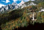 The Triglavska Bistrica Trail starts at Pri Rosu, at the valley’s entrance and runs up the valley. Most of the trail follows the paths along the Triglavska Bistrica and only meets the road through the valley in several short sections. It is 10 km long and the visit requires about 3 hours time. 1. The Slovenian Alpine Museum connects Slovene mountain climbers, alpinists, mountain rescuers and mountain guides. Permanent and temporary exhibitions represent the history of mountaineering in Slovenia. 2. Peričnik waterfall falls over the conglomerate lip in two stages. The lower, more popular and higher waterfall measures 52 m, and the upper waterfall in 16 m high. 3. Hummocky meadows are rare and rarely preserved surface on limestone. They are characteristic by gently undulating hummocks (tussocks). Hummocky meadows can be observed in mowed or grazed grassland. 4. The Triglav North Face is one of the mightiest and well known in the Alps. It is over 1000 m high and around 3000 m wide. The Triglavska Bistrica Trail starts at Pri Rosu, at the valley’s entrance and runs up the valley. Most of the trail follows the paths along the Triglavska Bistrica and only meets the road through the valley in several short sections. It is 10 km long and the visit requires about 3 hours time. 1. The Slovenian Alpine Museum connects Slovene mountain climbers, alpinists, mountain rescuers and mountain guides. Permanent and temporary exhibitions represent the history of mountaineering in Slovenia. 2. Peričnik waterfall falls over the conglomerate lip in two stages. The lower, more popular and higher waterfall measures 52 m, and the upper waterfall in 16 m high. 3. Hummocky meadows are rare and rarely preserved surface on limestone. They are characteristic by gently undulating hummocks (tussocks). Hummocky meadows can be observed in mowed or grazed grassland. 4. The Triglav North Face is one of the mightiest and well known in the Alps. It is over 1000 m high and around 3000 m wide.
The Radovna Cycle Route
 The cycleway runs along the Radovna valley, from Krnica near Zgornje Gorje to the Pocar Farm Museum at Zgornja Radovna. It is about 16 km long and takes 2.5 to 3.5 hours for a complete visit. IMPORTANT POINTS 1. Chalk Extraction – the Radovna valley is known as one of the best chalk locations in Europe. The lake Kreda at Srednja Radovna was created by water fl ooding the abandoned chalk pit after the pit was closed down in 1985 due to low profi tability. 2. The Pstnak mill and sawmill were built during the reign of Maria Teresa at the end of the 18th century. The mill and the sawmill could only operate periodically, when the water level was suffi ciently high. 3. The Gogala Linden Tree grows in front of THE Gogala Farm in Zgornja Radovna. The mighty tree is about 25 meters high, and measures more than two meters in diameter at breast height. Experts say that the tree is about 500 years old. 4. The Pocar Farm in Zgornja Radovna is one of the oldest well-preserved farms in the Triglav National Park. The Pocar Farm is a cultural monument managed by the Triglav National Park and houses a museum collection and TNP informa-tion point. The cycleway runs along the Radovna valley, from Krnica near Zgornje Gorje to the Pocar Farm Museum at Zgornja Radovna. It is about 16 km long and takes 2.5 to 3.5 hours for a complete visit. IMPORTANT POINTS 1. Chalk Extraction – the Radovna valley is known as one of the best chalk locations in Europe. The lake Kreda at Srednja Radovna was created by water fl ooding the abandoned chalk pit after the pit was closed down in 1985 due to low profi tability. 2. The Pstnak mill and sawmill were built during the reign of Maria Teresa at the end of the 18th century. The mill and the sawmill could only operate periodically, when the water level was suffi ciently high. 3. The Gogala Linden Tree grows in front of THE Gogala Farm in Zgornja Radovna. The mighty tree is about 25 meters high, and measures more than two meters in diameter at breast height. Experts say that the tree is about 500 years old. 4. The Pocar Farm in Zgornja Radovna is one of the oldest well-preserved farms in the Triglav National Park. The Pocar Farm is a cultural monument managed by the Triglav National Park and houses a museum collection and TNP informa-tion point.
Info: Informacijski center TNP Bled - Ljubljanska cesta 27 4260 Bled Slovenia
Tel. +386(0)4 / 578 02 00 Fax +386(0)4 / 578 02 01 -
This e-mail address is being protected from spambots. You need JavaScript enabled to view it
- www.tnp.si
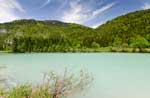
Bohinj & Bled
Find your true refl ection in nature’s mirror
 Walk around Lake Bohinj to the Savica Water-fall! The path takes you from the Church of St John in Ribčev Laz, which was built in the 14th century. This church features the styles dating from romanticism to baroque and several remains from the 1st to the 5th century A.D. were found there. The walk continues over the meadows of Fužinsko polje to the northern side of the lake. You can visit the Alpine Dairy Farming Museum in Stara Fužina, which is located in an old cheese dairy and presents the history of alpine dairy farming in Bohinj. The path leads you to the lake, which is the largest permanent lake in Slovenia. It has glacier origins and is located in the Triglav National Park. In the village of Ukanc, the path leads you forward to the foothills of the majestic Savica Wa-terfall, which was also featured in poetry by Slovenian famous poet Dr France Prešeren. You can return by riding the excursion boat on Lake Bohinj. Walk around Lake Bohinj to the Savica Water-fall! The path takes you from the Church of St John in Ribčev Laz, which was built in the 14th century. This church features the styles dating from romanticism to baroque and several remains from the 1st to the 5th century A.D. were found there. The walk continues over the meadows of Fužinsko polje to the northern side of the lake. You can visit the Alpine Dairy Farming Museum in Stara Fužina, which is located in an old cheese dairy and presents the history of alpine dairy farming in Bohinj. The path leads you to the lake, which is the largest permanent lake in Slovenia. It has glacier origins and is located in the Triglav National Park. In the village of Ukanc, the path leads you forward to the foothills of the majestic Savica Wa-terfall, which was also featured in poetry by Slovenian famous poet Dr France Prešeren. You can return by riding the excursion boat on Lake Bohinj.
Sightseeing beauties of Bled and refreshing summer fun in Vintgar gorge
 Start the tour from the centre of Bled around the lake through Spodnje Gorje to Vintgar gorge. Return back the same way or continue the walk through Zasip back to the centre of Bled. 1. You can reach Bled Island by Pletna or a rental boat. To the baroque church of Mary’s Assumption lead 99 steps, where the famous bell invites to the realization of hidden dreams. 2. Straža hill, 646 m altitude, offers excellent opportunities for recreation, either winter skiing or summer tobogganing and the adventure park on top. It is possible to take the chair lift or to use the legendary Rikli path. 3. Thousand years old Bled Castle is the oldest castle in Slovenia and one of the symbols of Slovenia. It offers a visit of the castle museum, printing works, wine cellar, herbal gallery and castle chapel. 4. 1,6 km long Vintgar gorge ranks among the most beautiful tourist attractions of Slovenia. Start the tour from the centre of Bled around the lake through Spodnje Gorje to Vintgar gorge. Return back the same way or continue the walk through Zasip back to the centre of Bled. 1. You can reach Bled Island by Pletna or a rental boat. To the baroque church of Mary’s Assumption lead 99 steps, where the famous bell invites to the realization of hidden dreams. 2. Straža hill, 646 m altitude, offers excellent opportunities for recreation, either winter skiing or summer tobogganing and the adventure park on top. It is possible to take the chair lift or to use the legendary Rikli path. 3. Thousand years old Bled Castle is the oldest castle in Slovenia and one of the symbols of Slovenia. It offers a visit of the castle museum, printing works, wine cellar, herbal gallery and castle chapel. 4. 1,6 km long Vintgar gorge ranks among the most beautiful tourist attractions of Slovenia.
Info: Turizem (Tic) Bohinj - Triglavska Cesta 30 4264 Bohinjska Bistrica
Tel. 00 386 4 574 75 90 -
This e-mail address is being protected from spambots. You need JavaScript enabled to view it
- www.bohinj.siTurizem Bled - Cesta svobode 11 4260 Bled
Tel. 00 386 4 578 05 00 -
This e-mail address is being protected from spambots. You need JavaScript enabled to view it
- www.bled.si
Kranjska Gora
Mojstrana-Rateče Cycle Track
A two-way cycle track leading from Mojstrana to Rateče is a former railroad. The path starts in the town of Mojstrana at the Slovenian Alpine Museum which offers visitors the insight into the popularity and signifi cance of mountaineering in Slovenia. The track than passes the town of Belca and reaches Gozd Martuljek that offers a scenic view of the Martuljek or Špik mountain range - part of the Triglav National Park since 1981. Behind the former hotel Špik, the cycle path turns to Kranjska Gora, which is the starting point for the trip to the Martuljek waterfalls. They are an extremely popular tourist attraction. Moving towards Kranjska Gora, the path leads through the old town centre, past the ethnographic museum the Liznjek Homestead. The house used to be a homestead and also a village inn. The track than winds under ski slopes to the town of Podkoren and past the nature reserve Zelenci. The cycle track continues to Rateče, namely beyond the country border, to Italy and Austria.
Hiking and tourist path to the three-country border
 You can start your trip in the centre of the village of Rateče, at the Kajžnk House - renovated building with very well preserved folk architecture. It’s an ethnographic museum where you can see a reconstructed traditional smoke kitchen and larder, the Rateče folk costume and regional history exhibition, and old films about the area’s surviving customs and famous Planica ski jumps. The path leads to the restaurant Šurc, where the visitor can get a short description of Rateče and main sights of this village at 850 m above sea level. Along the forest path to the 1509 m high mountain Peč numerous boards give hikers key information regarding Slovene-Italian border, pastures, grassland and the Julian Alps. After the Mountain Lodge Tromeja the trail splits into a longer and shorter one but joins again at the very end of the path – at the point of a three-country border, which is the junction of three countries, i.e. Slovenia, Italy and Austria. You can start your trip in the centre of the village of Rateče, at the Kajžnk House - renovated building with very well preserved folk architecture. It’s an ethnographic museum where you can see a reconstructed traditional smoke kitchen and larder, the Rateče folk costume and regional history exhibition, and old films about the area’s surviving customs and famous Planica ski jumps. The path leads to the restaurant Šurc, where the visitor can get a short description of Rateče and main sights of this village at 850 m above sea level. Along the forest path to the 1509 m high mountain Peč numerous boards give hikers key information regarding Slovene-Italian border, pastures, grassland and the Julian Alps. After the Mountain Lodge Tromeja the trail splits into a longer and shorter one but joins again at the very end of the path – at the point of a three-country border, which is the junction of three countries, i.e. Slovenia, Italy and Austria.
Info: TIC Kranjska Gora Turistične informacije & rezervacije zasebnih sob in apartmajev - Tičarjeva ulica 2 - 4280 Kranjska Gora
Tel. +386 (0)4 5809440 Fax +386 (0)4 5809441 -
This e-mail address is being protected from spambots. You need JavaScript enabled to view it
- www.kranjska-gora.si
Old Historical Town Centres – Jesenice, Radovljica, Tržič, Kranj, Škofja Loka
Green Kranj and mystical Škofja Loka
 Old town centres and interesting surrounding with reach cultural and natural heritage offer a lot of possibilities for sightseeing and exploration, tasting local gastronomy, cycling, hiking, bird watching and other activities. Old town centre of Kranj has been protected as cultural monument from the year 1983. We can place it as one of the rare exceptions in Europe where the river flowing through canyon in the central part of the town. There is an educational walking path where the guests can watch rare birds and plants. Treasures of the Gorenjska museum are on exhibition in the Town hall, typical sausage from the area known as Kranjska klobasa is served in a domestic restaurant named gostilna. Medieval Škofja Loka boasts with prominent castle, with colourful building façades, with one of the oldest stone bridges in Europe and old Nace’s house, one of the biggest monuments of Slovenian cultural heritage objects. Visitors can cycle to nearby Crngrob, village well known by the Church Mary’s Annunciation, one of the biggest and most beautiful artistic monuments of Gothic period in Slovenia. Old town centres and interesting surrounding with reach cultural and natural heritage offer a lot of possibilities for sightseeing and exploration, tasting local gastronomy, cycling, hiking, bird watching and other activities. Old town centre of Kranj has been protected as cultural monument from the year 1983. We can place it as one of the rare exceptions in Europe where the river flowing through canyon in the central part of the town. There is an educational walking path where the guests can watch rare birds and plants. Treasures of the Gorenjska museum are on exhibition in the Town hall, typical sausage from the area known as Kranjska klobasa is served in a domestic restaurant named gostilna. Medieval Škofja Loka boasts with prominent castle, with colourful building façades, with one of the oldest stone bridges in Europe and old Nace’s house, one of the biggest monuments of Slovenian cultural heritage objects. Visitors can cycle to nearby Crngrob, village well known by the Church Mary’s Annunciation, one of the biggest and most beautiful artistic monuments of Gothic period in Slovenia.
At the foot of Karawank
 From Tržič, the town of craft situated under Ljubelj, the path leads us by the foot of Karawank past the ruins of the Kamen castle into medieval Radovljica. From ironworks Jesenice is just a step from the town to blossom fields of daffodils. Old town centre Tržič still whispers stories about shoemakers, leather dealers, weavers and black-smiths. Forces of the river Tržiška Bistrica offered not only possibility of craft, but there were also some fossils from old terrestrial era exposed. Mighty ruins of the Kamen castle protect the entrance of the valley Draga. Radovljica enthuses with well preserved medieval town centre, manor, museums and several opportunities for recreation. Slovenian beekeeping has got its own monument in the world known museum. The charm of Jesenice is Stara Sava, which used to be ironworks settlement, and today is technical monument and museum of the miner’s history. The Golica with Zois Park should be visited to enjoy and admire white fields of daffodils locally named ključavnice. From Tržič, the town of craft situated under Ljubelj, the path leads us by the foot of Karawank past the ruins of the Kamen castle into medieval Radovljica. From ironworks Jesenice is just a step from the town to blossom fields of daffodils. Old town centre Tržič still whispers stories about shoemakers, leather dealers, weavers and black-smiths. Forces of the river Tržiška Bistrica offered not only possibility of craft, but there were also some fossils from old terrestrial era exposed. Mighty ruins of the Kamen castle protect the entrance of the valley Draga. Radovljica enthuses with well preserved medieval town centre, manor, museums and several opportunities for recreation. Slovenian beekeeping has got its own monument in the world known museum. The charm of Jesenice is Stara Sava, which used to be ironworks settlement, and today is technical monument and museum of the miner’s history. The Golica with Zois Park should be visited to enjoy and admire white fields of daffodils locally named ključavnice.
Info:Zavod Za Turizem Kranj, Tourist Board Kranj Glavni trg 2, 4000 Kranj
Tel. +386 4 2380 450 -
This e-mail address is being protected from spambots. You need JavaScript enabled to view it
- www.tourism-kranj.si
Žirovnica Municipality
The Trail where the Karavanke mountain ridges and Kamniško - Savinjske Alps meet
 The walking route along the most western part of the ridge Kamniško-Savinjske Alpe: Peči with the viewpoints over the highest peak in the ridge Karavanke: Stol and the flatlands Dežela with the Bled corner in the distance If we follow the direction from the parking place in Završnica across the dam, we should turn right when we cross it. A narrow forest path which follows a former narrowgauge track leads us through the tunnel to the water tank above Žirovnica where the view over the ten villages joined into The Žirovnica Municipality opens. We follow the path further along the ridge of Reber to the peak Gosjak where we turn back into the Valley Završnica. We can choose to turn right at the peak Brinov vrh and descend to the church Sv. Lovrenc. We return over the pastures on the slopes of the ridge Reber to the water tank and then descend to the path we followed from the parking place over the stairs "Mazovčeve štenge". We can diversify the walk by visiting the two waterfalls (the first being above the Breeding Bee-hive Station Kranjska čebela and the other above the lake). In the vicinity of the last waterfall, which is interestingly called "The devil washes the broad" nests the horned owl, an extremely rare and timid species of owls. We conclude the walk at the lake in Završnica, where it is also possible to fish. Length: 6 km. Altitude: 400 m. Time: 2.5 hrs. The walking route along the most western part of the ridge Kamniško-Savinjske Alpe: Peči with the viewpoints over the highest peak in the ridge Karavanke: Stol and the flatlands Dežela with the Bled corner in the distance If we follow the direction from the parking place in Završnica across the dam, we should turn right when we cross it. A narrow forest path which follows a former narrowgauge track leads us through the tunnel to the water tank above Žirovnica where the view over the ten villages joined into The Žirovnica Municipality opens. We follow the path further along the ridge of Reber to the peak Gosjak where we turn back into the Valley Završnica. We can choose to turn right at the peak Brinov vrh and descend to the church Sv. Lovrenc. We return over the pastures on the slopes of the ridge Reber to the water tank and then descend to the path we followed from the parking place over the stairs "Mazovčeve štenge". We can diversify the walk by visiting the two waterfalls (the first being above the Breeding Bee-hive Station Kranjska čebela and the other above the lake). In the vicinity of the last waterfall, which is interestingly called "The devil washes the broad" nests the horned owl, an extremely rare and timid species of owls. We conclude the walk at the lake in Završnica, where it is also possible to fish. Length: 6 km. Altitude: 400 m. Time: 2.5 hrs.
The MTB Cycle Route: Along the green mountain pastures in the lap of the Stol mountain
 Mountain bike route, which connects the archaeological site from the time of the downfall of the Roman empire with the shepherd’s cottages in the heart of the mountain ridge Karavanke and the panoramic view over the valley "Gornjesavs-ka dolina" and the flatlands "Dežela." We ascend from the parking place in the Valley Završnica along the macadam road towards the mountain hut Valvazorjev dom. 300 m before reaching the hut turn towards Ajdna, which can be reached only on foot. Ajdna offers one of the most beautiful views in this part of Slovenia. There are the remnants of the settlement from late Antiquity. We continue our route towards the mountain pasture Potoška planina, where we turn right towards the mountain hut Valvazor-jev dom. There’s a road that leads from Valvazor-jev dom past the cottage on the mountain pas-ture Žirovniška planina towards the next mountain pasture Zabreška planina, from where we descend back to the valley. The mountain pastures along the route are full of flowers and many of them are protected and prohibited for picking. We can leave the bike on the last sharp turn right (under the shrine) and visit one of the most beautiful local sights, the cave Turška jama (5), where the locals sought refuge from the Turkish invasions. Length: 20 km. Altitude: 880 m. Time: 3.5 hrs. Mountain bike route, which connects the archaeological site from the time of the downfall of the Roman empire with the shepherd’s cottages in the heart of the mountain ridge Karavanke and the panoramic view over the valley "Gornjesavs-ka dolina" and the flatlands "Dežela." We ascend from the parking place in the Valley Završnica along the macadam road towards the mountain hut Valvazorjev dom. 300 m before reaching the hut turn towards Ajdna, which can be reached only on foot. Ajdna offers one of the most beautiful views in this part of Slovenia. There are the remnants of the settlement from late Antiquity. We continue our route towards the mountain pasture Potoška planina, where we turn right towards the mountain hut Valvazor-jev dom. There’s a road that leads from Valvazor-jev dom past the cottage on the mountain pas-ture Žirovniška planina towards the next mountain pasture Zabreška planina, from where we descend back to the valley. The mountain pastures along the route are full of flowers and many of them are protected and prohibited for picking. We can leave the bike on the last sharp turn right (under the shrine) and visit one of the most beautiful local sights, the cave Turška jama (5), where the locals sought refuge from the Turkish invasions. Length: 20 km. Altitude: 880 m. Time: 3.5 hrs.
Info: Zavod za turizem in kulturo Žirovnica - Žirovnica 14 4274 Žirovnica
Tel. +386 4 580 15 03 -
This e-mail address is being protected from spambots. You need JavaScript enabled to view it
- www.zirovnica.eu
Selška and Poljanska valley
Find inspiration in the Selška valley
 The trail will lead you through Selška valley where you can observe smaller villages and beautiful nature. In Železniki and in Sorica you will see where the inhabitants of Selška valley found their inspiration for their diverse creations. In Železniki you can walk through nicely renovated centre and if you are interested in getting more information about ironworks industry, you can go to Museum Železniki, where you can see also the exhibition of bobbin laces. By prior arrangement the Museum staff can also demonstrate one of many crafts – blacksmithing, bob-bin lace making or making of Dražgoše honey bread. The trail then leads to the village Sorica, where you can visit the birthplace of famous painter Ivan Gorhar. By prior arrangement you can also take a look at the copied collection of Grohar work or you can participate in art or music workshop. After the lunch in nearby restaurant you can spend your afternoon actively and take a walk through one of the pathways (Architectural heritage trail, trail to the waterfall Sprucar, on the mountain Ratitovec,...). The trail will lead you through Selška valley where you can observe smaller villages and beautiful nature. In Železniki and in Sorica you will see where the inhabitants of Selška valley found their inspiration for their diverse creations. In Železniki you can walk through nicely renovated centre and if you are interested in getting more information about ironworks industry, you can go to Museum Železniki, where you can see also the exhibition of bobbin laces. By prior arrangement the Museum staff can also demonstrate one of many crafts – blacksmithing, bob-bin lace making or making of Dražgoše honey bread. The trail then leads to the village Sorica, where you can visit the birthplace of famous painter Ivan Gorhar. By prior arrangement you can also take a look at the copied collection of Grohar work or you can participate in art or music workshop. After the lunch in nearby restaurant you can spend your afternoon actively and take a walk through one of the pathways (Architectural heritage trail, trail to the waterfall Sprucar, on the mountain Ratitovec,...).
Wandering around beautiful Poljanska valley
 On the trip through Poljanska valley you can see the Tavčar mansion in Visoko, Rupnik line forts and in Žiri you can learn something more about the crafts and also take a walk to a popular walking point, St. Ana church in Ledinca. You can start your trip in Visoko with a visit of writer Ivan Tavčar’s mansion and then continue with a view of Rupnik line forts. The trail starts at a local bio farm and leads from Hrastov hill fort to Javorč, popular hiking point. The inner side of forts can only be seen with a guide. We recomend to make a stop and refreshment in one of the tourist farms or in one of the restaurants and then heading forward to Žiri. In Žiri you can see the museum collection of shoemaking and the collection of bobbin laces. To conclude the day, we suggest to take a walk to popular walking point in Žiri, St. Ana church in Ledinca. On the trip through Poljanska valley you can see the Tavčar mansion in Visoko, Rupnik line forts and in Žiri you can learn something more about the crafts and also take a walk to a popular walking point, St. Ana church in Ledinca. You can start your trip in Visoko with a visit of writer Ivan Tavčar’s mansion and then continue with a view of Rupnik line forts. The trail starts at a local bio farm and leads from Hrastov hill fort to Javorč, popular hiking point. The inner side of forts can only be seen with a guide. We recomend to make a stop and refreshment in one of the tourist farms or in one of the restaurants and then heading forward to Žiri. In Žiri you can see the museum collection of shoemaking and the collection of bobbin laces. To conclude the day, we suggest to take a walk to popular walking point in Žiri, St. Ana church in Ledinca.
Info: Turizem Škofja Loka - Kidričeva cesta 1a 4220 Škofja Loka
Tel. 04/51 70 600 -
This e-mail address is being protected from spambots. You need JavaScript enabled to view it
- www.skofja-loka.com
|


")
")